Layer control
The layer control is split into two sections:
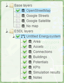
Base layers
ESDL layers
The base layers section allows you to choose the backgorund of the map, either openstreetmap (the default), google or no map. The latter one can be used for schematic diagrams where the physical location is not important.
In the ESDL layer section you will find one item for each ESDL loaded in the MapEditor. The ESDL information is separated in different layers that can each be shown or hidden. See the table below for a detailed description of the different ESDL sub layers.
Layer |
Description |
|---|---|
Area |
Layer showing the area boundaries |
Assets |
Layer showing all ESDL assets |
Connections |
Layer showing logical connections between assets |
Buildings |
Layer showing building geometries |
Potentials |
Layer showing energy potential information |
KPIs |
Layer showing KPIs |
Simulation results |
Layer showing simulation results, like animation of loads |
Notes |
Layer showing the notes |